Hurricane Gordon as studied by the
Hurricane Intercept Research Team
on Sunday, September 17, 2000
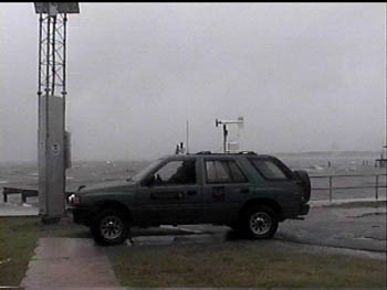
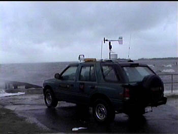
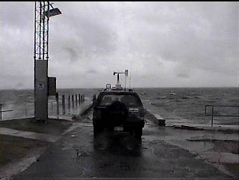
Here are some shots of our Isuzu Rodeo that has been specially modified to do hurricane field work.
As the afternoon wore on, and Gordon closed the distance between us and itself, we began to wonder if the 9 hour trip was going to be worth it. Afterall, we were there to gather as much data as we could on this system; no matter how weak it was. And it was weak...relatively speaking. With hurricanes like Bertha, Fran, Bonnie, Dennis and Floyd under our belts, a weak hurricane (and soon to be downgraded tropical storm) was almost no big deal. But we were studying out first Gulf cyclone. And we were in Florida.....not North Carolina. So, we did several media interviews and talked amongst the many storm chasers that had come from all over the Southeast U.S. It was like Cedar Key was home to the "2000 Hurricane Chasers Convention". Everyone was serious about their respective work. No one had a bad attitude or any superiority complexes. It was a nice gathering of experienced storm chasers who were about to witness a rather unique event.
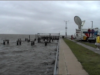
This picture shows the Cedar Key waterfront looking into the Gulf of Mexico. Notice how calm (although gray) everything looks. The wind is picking up slightly but not much rain is falling.
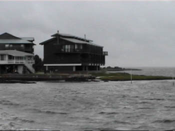
Here is another still shot of the relatively calm Gulf of Mexico. This scene would change dramatically in less than 5 hours.
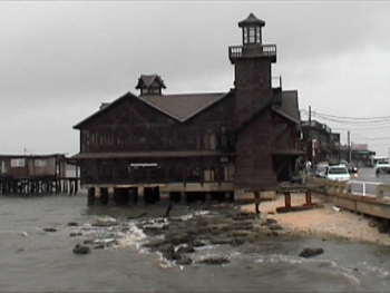
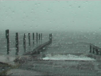
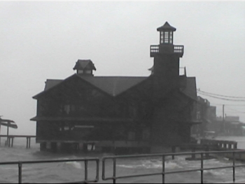
And yet another shot: this building that sits on pilings in the water....we never did ask what the building is...perhaps a restaurant or something (we found out it is called the "Sea Breeze Restaurant"- now that's quite a name, huh?). Wait until you see what it looks like when we videoed it a few hours later.
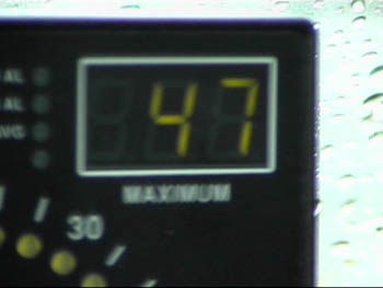
Now the wind has peaked at 47mph on our vehicle's anemometer. It is about 2:30pm Sunday afternoon. The storm is still about 7 hours away.
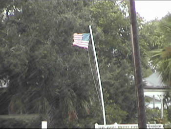
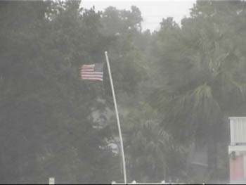
This photo also has a video clip associated with it. Flags blowing in the wind/rain are always a common sight during a hurricane.
Click Here to see the video clip of the photo above.
As Gordon draws closer, a brief burst of convection (thunderstorm activity) develops and moves in our direction. The Hurricane Hunters have been checking out Gordon with their airplane and report that the pressure is slowly rising...indicating that Gordon is at least not strengthening. The time is close to 4pm now and Gordon is only about 70 miles away (the center of the hurricane...keep in mind that we were feeling the effects well out ahead of the center).
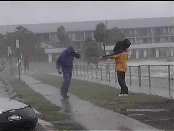
While conditions gradually deteriorate, a news crew braves the increasing wind and stinging rain to file a report for a local TV station.
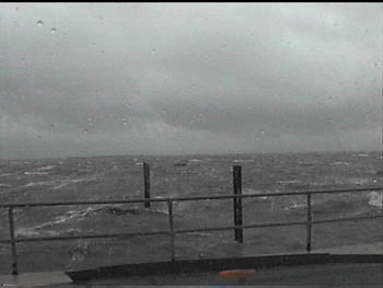
The Gulf of Mexico was beginning to come alive. The choppy waters of earlier in the afternoon quickly turned to rough, stormy seas. Note that because Cedar Key is on the west coast of Florida, the winds around Gordon blew almost offshore for a good while until the storm was almost at our latitude....and the winds switched to an onshore direction....this really increased the wave action.
Here is another photo of the building seas of the Gulf of Mexico.
And here is another shot of the flag blowing in the wind. There is also another accompanying video clip. Notice how the intensity of the wind and rain is increasing.
Click Here for the video clip of the photo above.
In this section, we want show how quickly things can change. Granted the tide was rising as a high tide was going to occur late in the afternoon. But, the wind direction was now also becoming more onshore.....thus a little more water was being pushed into the Cedar Key area. Look at the two photos below. The one on top was taken at around 2:30pm and the one on the bottom was taken around 4:30pm. Notice the increase in waves as well as the rising water level.
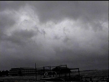
We mentioned that Gordon had a brief burst of convection (thunderstorm activity) just prior to making landfall, here is a photo of the much thicker and lower cloud cover that was moving onshore. The clouds would also bring more rain than we had seen in the first few hours.
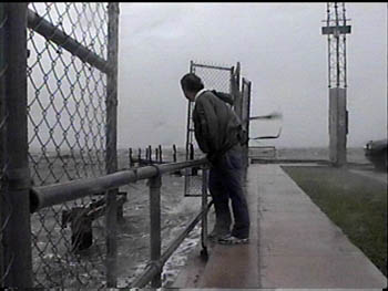
While the wind and rain increased, we met a guy named Rodney. He was standing at the rail looking into the wind and was pelted by rain. As part of our safety equipment, we have two pair of high-impact safety goggles. We quickly suggested to Rodney that he wear them while facing the wind. He was able to stare into 60 mph wind with stinging rain and appreciate what was happening there at Cedar Key.
Here is a video clip of Rodney before we gave him the goggles.
And a video clip of Rodney wearing the goggles.
Now things were really getting interesting. Gordon was closer than ever, although it had been downgraded to a tropical storm, Gordon was still packing at least 70mph wind, heavy rains (in some locations) and the potential for a storm surge here at Cedar Key. The photo below and accompanying video clip show the large waves that were breaking against the seawall at Cedar Key.
The next set of video clips are quite dramatic. They show the waves crashing onshore Cedar Key near the height of the storm. We had wind speeds on the vehicle of 60 to 65 mph gusting to well over 75 mph. Check out the clips below:
Mark Sudduth gets a surprise wave while sitting in the H.I.R.T. truck.
Here is a great shot of the wind driven waves blasting into the waterfront of Cedar Key.
This video clip shows Mark Sudduth with the Gulf of Mexico behind him. Mark is filming the waterfront using a SCUBA camera housing with our Digital-8 inside. Eddie shot this clip from inside the H.I.R.T. truck.
This clip was shot using the H.I.R.T. truck as a shield against the blasting wind and waves. The storm is about to make landfall now and the wind is just about as high as it is going to get.....and so are the waves!
This clip was shot from inside the H.I.R.T. truck just as a large crahed ashore. Listen carefully as you can hear the infamous sound of hurricane wind in the background.
Another good clip as a series of large waves batters the shoreline at Cedar Key.
We used our night shot function to get this video clip.
We departed the Cedar Key area around 9:30pm that Sunday night. The power went out and the island was dark except for the lights of emergency crews, storm chasers and news trucks. Eddie and Mark were quite exhausted and headed back to Gainesville to our hotel room. Oddly enough, our highest wind reading occured as we were leaving the island: 76 miles per hour! This was just over hurricane force. Gordon had made landfall very near to Cedar Key.
What did we learn by going to Cedar Key? Well for one thing, a tropical cyclone can have many tricks in its bag. Remember, we left Wilmington, NC around 3am Sunday morning with a temperature of around 50 degrees. The air was dry and cool in the Carolinas. Once we arrived in Florida, the air temperature was only about 65 degrees or so. As Gordon approached us, the air temp went up to a balmy 76 degrees. Because hurricanes and tropical storms are warm systems, we were able to really see first hand how that part of tropical meteorology works.
We also learned more so than ever that it only takes a good 60 to 70 mph sustained wind across an open body of water to pile it up somewhere. In this case: Cedar Key and the Gulf Coast nearest to Gordon's landfall. The waves were crashing into the seawall there at Cedar Key giving quite a dramatic scene to all who witnessed it. And no one got hurt. It was a storm that was perfect for us to get close enough and have a little fun. Other storm chasers and on-lookers joined in as well. We respect the power of Nature but were glad to have some "relaxing" moments while large swells pounded the shoreline around us. We could peer into the storm with our safety goggles knowing that people would not suffer much loss with this storm. Knowing what devastation hurricanes can inflict upon the lives of humans and their environment, for a few hours that day, we could step inside the realm of the planet's most powerful weather system and be a part of something that is difficult to describe. That is why we go there. To bring it back and share as much as possible with whoever wants to see "virtually" what we saw. Hear "virtually" what we heard. By being there in person, with all of our sophisticated equipment, a video camera and a desire to understand hurricanes better, we just might spark the interest of a kid to become the next Jim Cantore or Jeff Flock, CNN Newscaster or even a Hurricane Interceptor. But more importantly, we hope to spark an interest in the public to take precautions when directed to do so. One day, sooner rather than later, the next Gordon will not be so tame. It will be a monster with a name like Andrew or Hugo or even Camille....
....either way, you track it, we'll take you there!!!
|
|

