
|
The Saffir-Simpson Hurricane Damage Potential Scale was created to allow meteorologists, emergency management officials and the public to have some idea of what to expect when a hurricane makes landfall. Wind speed and barometric pressure are the primary measuring factors as storm surge height is highly dependant upon the coastline (near shore and offshore) of the area affected by the hurricane. There are five (5) categories in the Scale with 1 being the weakest and 5 being the strongest. Note that three category 5 hurricanes have struck the U.S. mainland since 1900: the Labor Day hurricane of 1935, Hurricane Camille in 1969 and hurricane Andrew in 1992. We have created a computer generated barrier island scene to try and help you visualize what each of the categories of hurricanes might do in terms of destruction. Keep in mind that the images below are only computer generated renderings of possible outcomes of the associated category hurricane. There are vast differences in the amount of damage that can be done from category to category, all depending upon geography, tide, and a little luck. Also keep in mind that the images below DO NOT show the large, battering waves that accompany a hurricane along the beachfront. This first image shows a typical beach scene on a small town barrier island at the end of a hot, hazy summer day.  CATEGORY ONE HURRICANE Winds 74-95 mph (64-82 kt or 119-153 kph). Storm surge generally 4-5 ft above normal. No real damage to building structures. Damage primarily to unanchored mobile homes, shrubbery, and trees. Some damage to poorly constructed signs. Also, some coastal road flooding and minor pier damage. Hurricanes Allison of 1995 and Danny of 1997 were Category One hurricanes at peak intensity.  CATEGORY TWO HURRICANE Winds 96-110 mph (83-95 kt or 154-177 kph). Storm surge generally 6-8 feet above normal. Some roofing material, door, and window damage of buildings. Considerable damage to shrubbery and trees with some trees blown down. Considerable damage to mobile homes, poorly constructed signs, and piers. Coastal and low-lying escape routes flood 2-4 hours before arrival of the hurricane center. Small craft in unprotected anchorages break moorings. Hurricane Bonnie of 1998 was a Category Two hurricane when it hit the North Carolina coast, while Hurricane Georges of 1998 was a Category Two Hurricane when it hit the Florida Keys and the Mississippi Gulf Coast.  CATEGORY THREE (MAJOR) HURRICANE Winds 111-130 mph (96-113 kt or 178-209 kph). Storm surge generally 9-12 ft above normal. Some structural damage to small residences and utility buildings with a minor amount of curtainwall failures. Damage to shrubbery and trees with foliage blown off trees and large tress blown down. Mobile homes and poorly constructed signs are destroyed. Low-lying escape routes are cut by rising water 3-5 hours before arrival of the hurricane center. Flooding near the coast destroys smaller structures with larger structures damaged by battering of floating debris. Terrain continuously lower than 5 ft above mean sea level may be flooded inland 8 miles (13 km) or more. Evacuation of low-lying residences with several blocks of the shoreline may be required. Hurricanes Roxanne of 1995 and Fran of 1996 were Category Three hurricanes at landfall on the Yucatan Peninsula of Mexico and in North Carolina, respectively.  CATEGORY FOUR (MAJOR) HURRICANE Winds 131-155 mph (114-135 kt or 210-249 kph). Storm surge generally 13-18 ft above normal. More extensive curtainwall failures with some complete roof structure failures on small residences. Shrubs, trees, and all signs are blown down. Complete destruction of mobile homes. Extensive damage to doors and windows. Low-lying escape routes may be cut by rising water 3-5 hours before arrival of the hurricane center. Major damage to lower floors of structures near the shore. Terrain lower than 10 ft above sea level may be flooded requiring massive evacuation of residential areas as far inland as 6 miles (10 km). Hurricane Luis of 1995 was a Category Four hurricane while moving over the Leeward Islands. Hurricanes Felix and Opal of 1995 also reached Catgeory Four status at peak intensity. 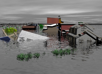 CATEGORY FIVE (MAJOR) HURRICANE Winds greater than 155 mph (135 kt or 249 kph). Storm surge generally greater than 18 ft above normal. Complete roof failure on many residences and industrial buildings. Some complete building failures with small utility buildings blown over or away. All shrubs, trees, and signs blown down. Complete destruction of mobile homes. Severe and extensive window and door damage. Low-lying escape routes are cut by rising water 3-5 hours before arrival of the hurricane center. Major damage to lower floors of all structures located less than 15 ft above sea level and within 500 yards of the shoreline. Massive evacuation of residential areas on low ground within 5-10 miles (8-16 km) of the shoreline may be required. Hurricane Mitch of 1998 was a Category Five hurricane at peak intensity over the western Caribbean. Hurricane Gilbert of 1988 was a Category Five hurricane at peak intensity and is the strongest Atlantic tropical cyclone of record.  
 |