
|
Welcome to HurricaneTrack.com's "Isabel" summary. I plan to post a commentary on the events leading up to our historic mission to cover, document and observe hurricane Isabel as it made landfall in North Carolina. I will pepper the commentary with photos and video clips where appropriate. There is also a link to the raw wind data collected on our RM Young anemometer that was placed atop our Chevy Tahoe. The total anemometer height was 14.6 feet above the ground. Let's start at the beginning.... At 9 am EDT on September 6, the NHC issued its first advisory on what would become one of the most hyped hurricanes that I can remember. Isabel was born. People say that they have funny feelings or a gut feeling about a certain storm or hurricane. I usually do not. It will go where ever it will go. But something about the name "Isabel" made me wonder if this one was destined for the history books. Early on, it was clear that Isabel would be a hurricane. The first NHC cyclone discussion for Isabel showed that it would be a hurricane soon. Little did anyone know how strong a hurricane it would become. As far as track forecasts went, overall, Isabel was as close to perfect as I have ever seen the NHC nail it. But in the beginning days of Isabel's track, I was wondering if Fabian's path had left a hole or weakness in the monster subtropical ridge of high pressure that dominated the Atlantic. If so, then Isabel would simply follow Fabian and miss land areas completely. If not, then perhaps the ridge of high pressure would build back in- stronger than before even. This would push Isabel on a more westward track. 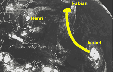 Here is a little animation showing the early ideas that I had for Isabel. Would it follow Fabian and turn out to sea- most TV meteorologists that I watched thought so. However, there were hints in the global models that Isabel could come at least a few degrees of longitude farther west. Time would tell. On September 8th, I had a meeting with the Marine Corps League, Disaster Relief Unit 1 out of Charlotte, NC. This Lowe's supported group of retired Marines was set up to offer help, food and water after a disaster- in this case, a hurricane. My job was to act as a consultant to their group and get them up to speed on how to track hurricanes and what info I look at to help determine a landfall location. It was ironic that our first formal meeting together took place one week to the day before H.I.R.T. and HurricaneTrack.com would begin full coverage of Isabel. I had helped to prep the Marines who would be needed once again to serve their country. I felt such a sense of accomplishment after leaving the meeting. The drive home I thought about how much these men cared and how well prepared they were in their first year. I also knew that they had a good chance of putting their preparedness to the test. It looked like Isabel could head towards the United States. Also by the 8th of September, Isabel had grown into a category two hurricane. The forecast called for more intensification and a track that would put the hurricane just to the north of the Leeward Islands (Antigua, Barbuda, Anguilla, etc.). This is pretty much exactly what happened- except for one small difference:  Isabel had far exceeded the intensity forecasts of the NHC and was a rare category five hurricane. The top winds were near 160 mph with a measured air pressure of 920 milibars. This was the first cat-5 hurricane in the Atlantic Basin since Mitch in 1998. However, the NHC readily admits that intensity forecasts are where the most improvements are needed. We're talking about trying to understand what drives the biggest heat engine on the planet. And we're (humans) trying to figure it all out with computer models using 0s and 1s. The NHC was probably as surprised as I was at this rare event- but at least it was not affecting land areas. Not yet. By the morning of the 13th, it was clear that Isabel would threaten, if not hit, the Southeast United States. Actually, several days earlier, I was pouring over global computer models trying to figure out from my own point of view where this hurricane might be headed. On Friday the 12th, I told people on the radio interviews that I began doing for WBT AM 1110 in Charlotte and WPTF AM 680 in Raleigh, that they needed to know where Isabel was forecast to track come Monday morning the 15th. That day, I felt, was the point of no return. It was either in the cards for a hit- or not. The rest of the weekend, September 13 and 14, I began preparing my group and our vehicles for the week ahead. Isabel was still a powerful and dangerous hurricane- but had begun to lose some of its punch. Begin Part Two: On Friday, September 12, I heard from my friend Jeff Flock from CNN. He and I worked together on hurricanes Dennis, Floyd and Lili. His reporting style has been seen by millions ever since I can remember- dating back to Hugo in 1989. Jeff sent me an email wondering what the plan was as far as H.I.R.T. was concerned. I told him that the models generally agree that North Carolina's Outer Banks and points north should be the main target area. He said he would touch base with me later in the weekend to make final plans. By Sunday the 14th, I was almost certain that Isabel would come very close if not right over Cape Hatteras. Keep in mind that I am talking about the center here. The hurricane was beginning to spread out and exert its influence over a larger and larger area. My team was interested in getting as close to the eye as possible. On Sunday the 14th, it looked like Buxton, NC would be a good starting point. I emailed Jeff at CNN to let him know. I told him that we should talk on the phone to plan things out more thoroughly. I also emailed the Dare Co. director of Emergency Management- Sandy Sanderson- to ask about procedures for getting on to the Outer Banks. One thing that my team does not do is disobey orders. If someone does not want us in their area, we leave. However, since 1999 when I started H.I.R.T., not one law enforcement official in over 10 hurricanes or tropical storms that we've been in has ever asked us to leave. But if they did, we would. This is an important issue since Dare Co. has a group of people who decide about evacuations. I wanted them to know that we were headed out there to observe, report and work with them to pass along storm related information. Their director emailed me back and told me that once the order to leave was given, I'd have to go. He urged me to read an account on the 1933 hurricane by well known hurricane historian Jay Barnes. Sandy did wish me and the team good luck. He said that he would be very busy- so visiting him on our way to Buxton would not be a likely. Meanwhile, Jeff Flock and I talked about the possibilities. I told him about the harsh conditions of the Outer Banks. We agreed that starting in Buxton would work ok- and if we had to leave, we'd find another place to do our work. CNN's issue was losing the satellite truck in even minor flooding or high winds. Obviously, the safety of the crew was the most important factor- but the crew is not the size a large truck with a concave dish the size of your living room pointed at the sky. There was a chance that we'd have to leave the Outer Banks for safer ground. We knew that from the beginning. I had also talked to my buddy Jim Edds about where he should set up. Jim films hurricanes and does not have to worry about weather equipment etc. He goes out and gets the best shots he can. Since I know the area, he asked for my advice. I told him that the Outer Banks were the likely target for Isbabel and that he could get stuck out there for a few days if he's not careful. On Monday morning my life was about to change. I had more radio interviews set up with stations all across the country. I was working with WPTF, WBT, WBAL, WGNI, WAAV and the Michigan Radio Network for up to the minute information about Isabel. However, these stations were also interested in (even more so) my plans to "chase the hurricane". Of course, hurricane chasing is a mis-nomer. You don't chase a hurricane- unless you left home too late. You chase down a tornado, you intercept a hurricane. If you intercept a tornado, well, it's been nice knowing you. Anyway, I was briefing the radio world and was also preparing the Tahoe for the mission. I knew already that I would not have to take the Rodeo with us on this one. We are saving it for something special. There is a lot to pack for a mission to observe and study a hurricane. At least this was in my backyard. I grew up in North Carolina and know the area very well. I also knew that North Carolinians were used to hurricanes- especially since we had just gone through the 5 landfalls of the late 90s. North Carolina was ready for Isabel. As the day wore on, I talked with CNN about their plans. Jeff had sent a sat-truck to Wilmington from Chicago. It would be CNN's own sat-truck that Jeff could use to follow H.I.R.T. for the entire mission. His plan was to have me on at 5pm EDT Monday to set the stage for the remainder of the week. I was busy looking at computer models, making sure all the gear was in place, updating radio stations, and doing the other usual things that I do: pick up the kids from school, feed them, take care of them etc. I was juggling a lot and had some great help from folks who were there when I needed them (you know who you are!). Jeff and his crew were on the ground in Wilmington by 3pm. I had all my stuff ready for the 5pm live shot from Wrightsville Beach. I did an update for WPTF in Raleigh on the way to the live shot and arrived with about 8 minutes to spare. Everything could have gone wrong. There were bridges to cross that could go up to let boat traffic through- stoplights, slow drivers, you name it. If you're in a hurry in Wilmington (my hometown for those of you who don't know that), you're in trouble. There are obstacles at every turn. But on Monday the 15th, all went smoothly. I made it on the air with Jeff for the 5pm shot on CNN to go over our plans for the week. Below are some photos of Wrightsville Beach during that evening. 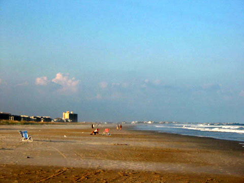 This is Wrightsville Beach looking north.  Notice how clear the sky was- yet the swells from distant Isabel were already impacting the coast. 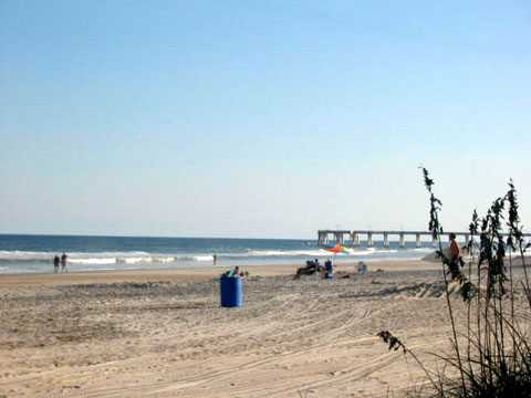 Another look at Wrightsville Beach- now looking southward. Again, notice how clear the sky was. While all this was going on, Isabel was getting closer. The five day forecast from the NHC now showed Isabel coming in just west of Cape Hatteras and across the Pamlico Sound. This painted a grim picture for folks along the Outer Banks and points north. They would all be within the right-front quadrant. This is where the maximum effects of a hurricane are usually felt. Jim Edds had left his Florida Keys home to film Isabel. My team was leaving for Buxton Tuesday morning. The media was getting into place as well. It was setting up to be one of the most heavily covered hurricanes in history. As we would find out later in the week, there was interest in this hurricane from people half way around the world. Begin Part Three By Monday night, all of H.I.R.T.'s plans were in place. The latest discussion from the NHC on Isabel continued to show that the Outer Banks of North Carolina would take the first strike from this hurricane. I had talked things over with my close colleagues, Jesse Bass and John Van Pelt. We were ready for this event. Now, all we needed was a good night's sleep and we would hit the road early Tuesday morning. The goal was to arrive on the Outer Banks that evening. Jesse, who lives in Portsmouth, VA, would drive down to Buxton or another area close by and meet John and me. John lives in Raleigh and he would drive to Wilmington early Tuesday. The plan was in place. It was time to get to work. As usual, I stayed up late- probably too late- looking over the global computer models. They all told the same story: a landfall in eastern North Carolina by Thursday night. I was satisfied with what I read and turned in for the night. Tuesday, September 16 I was up early Tuesday for a 7am live shot with CNN once again from Wrightsville Beach. All of that went off as planned and we packed our last remaining pieces of equipment and prepared to depart the area. John was driving to Wilmington with his StormStudy Dodge truck. We were to meet at my office and make last minute checks on everything before heading out at 9am sharp. That too worked as planned. There is a lot that can go wrong- even early on- before you even leave. Flat tires, family crises, you name it, it can happen. This day, it did not. We were all set to leave. We did stop to gas up and pick up some minor items needed for the mission. By 10am, we were on Highway 17 north heading out of Wilmington. Now keep in mind that the NHC issues advisories, full advisories, every 6 hours. The last one was at 5am EDT. There was another one, an all too important one, due out near 11am EDT. By that time, John, the CNN crew and I were nearing Jacksonville, NC in the middle of scrub pine and open land. However, I am very fortunate to have the support of Sprint PCS and their PCS Vision Connection Card. This little card is the key to how I operate once out of our office. At the office, I have broadband Internet. On the road I have near-broadband Internet thanks to Sprint. This is more than just a plug for our sponsor. I simply cannot do my job of gathering the latest info on the hurricane without it. I also could not relay the information that I do back to HurricaneTrack.com. There would be no pictures until after the hurricane was long over. With the PCS Connection Card, I can remain online anywhere on the Sprint PCS network. This would prove critical Tuesday morning.  This is what the Connection Card looks like. I was talking with Jesse back at his home in Portsmouth for most of the morning; once John and I departed Wilmington. He was looking at the same data that I would be able to look at once I pulled over to prepare the 11am EDT update from the NHC. It was about 10:41am when I pulled off to the side of Hwy 17. I took a look at the latest info from the NHC and realized that perhaps we did not need to go to Buxton afterall. The track kept shifting more and more to the west with each advisory. This was a huge turning point since we could easily save 3 to 4 hours of driving if we decided to head out to the Crystal Coast instead. After I wrote the update for HurricaneTrack.com, I talked things over with Jesse and Jeff Flock from CNN. It became clear that we did not need to go to Buxton. Atlantic Beach would suffice. Remember our goal: we wanted to be as close to the eye as possible when it made landfall. Atlantic Beach seemed to be well placed for this objective. We could at least stage there and move east or west as needed once the hurricane approached the coast. We also knew that this track would absolutely keep Cape Hatteras and points north in the right-front quadrant; easily sending a devastating overwash (storm surge) across the barrier islands. So we changed course and headed to Atlantic Beach. Our route lead us through my childhood home town of New Bern. We stopped at the Lowe's store and met with the manager as well as numerous customers. Everyone was curious about our trucks and the equipment on top. There were plenty of people stocking up on their hurricane supplies. Because North Carolina has seen so many hurricanes in the last few years, there was not a sense of panic. People were busy, but not scared. Some even shrugged off the prospect of another hurricane. For the most part, the mood was positive and we felt that everyone we interacted with appreciated what we were doing. Gathering data and other observations on the ground is important at understanding exactly what happens when a hurricane makes landfall. The folks we met throughout our mission really seemed to get that point. From New Bern, we headed out Highway 70 east. This is a route I've been on many, many times as a kid. My parents would take me to Atlantic Beach or Emerald Isle several times over each summer that I lived in New Bern. This time, I was leading an effort to study a hurricane as it made its way onshore. 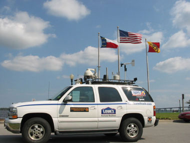 This photo was taken at Union Point along the New Bern waterfront. We had no real trouble getting a hotel room on Atlantic Beach. We stayed at the Sheraton where we were put on the 9th floor. From that vantage point, I set up the web cam and left it running for almost 24 hours straight. This was all on wireless Internet access through the PCS Connection Card. Folks all around the world could see a new image load every 10 to 12 seconds. The image was of the Atlantic. That afternoon and evening, it was full of ocean swells. The sky was as clear as one could ask for. Except for the large, rolling swells, you would never know a hurricane that used to be the strongest category possible was closing in on us.  View of the Sheraton from the Ocean side. Note the crystal clear skies. 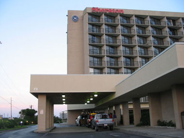 And a shot of "home" from another angle. 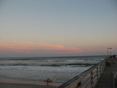 This photo shows a small area of clouds out over the Gulf Stream. These were not from Isabel yet.  I never get tired of seeing a good sunset. This was taken from the pier at the Sheraton. Later on in this re-cap, I'll post a video clip link where you can hear the roar of the ocean swells rolling in from this pier. 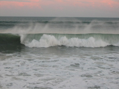 Here is a great shot of the breaking waves sent out by distant hurricane Isabel. As the evening wore on, we witnessed a fantastic sunset. The wind was blowing steadily out of the north and all you could hear was the roar of the ocean. There was an excitement in the air that I cannot describe. None of us want to see a hurricane hurt people. We do not go out to film the worst possible damage that we can and then sell it to TV. Our job is the data and observation gathering side of hurricane research. Just like the NOAA scientists certainly get pumped about a flight into the eye, we get just as excited about our work on land. It all matters. But our excitement is never because of the damage that is sure to come. You have to be there in person to understand what I mean. By Tuesday night, we were settled in at the Sheraton and had quite a set up of laptop computers, web cams and video recording equipment. We ate dinner in Morehead City after doing some evening work with CNN. The mood of the town was calm but on alert. Few thought that the area would be devastated, but no one was letting their guard down either. We were able to venture out to the end of the pier at the Sheraton later in the evening. The sun had set, so it was very dark to our south- over the open Atlantic. Out of nowhere, huge ocean swells would come in to the light of the pier and adjacent hotel. It was almost like seeing something come at you from the Abyss. I know that sounds overdone, but these waves were silent until they reached just beyond the end of the pier. Then, all you could see was the white foam as they began to crash. The pier shook and rocked a little. It was quite an impressive display of the energy of the ocean. And still, Isabel was far out in the Atlantic. Not a drop of rain had fallen as of yet. The skies were clear except for a few lonely thunderstorms over the Gulf Stream. That would change come sunrise on Wednesday. Wednesday, Setpember 17 After a decent night's sleep, we were up early on Wednesday. We had more work to do with CNN that morning as things really began to ramp up. Their was a thin veil of cirrus outflow clouds that had spread in over us from the south and east. I have this on time-lapse as you can see on the Isabel video clips in our Video Gallery. Watch it closely, play it a few times, notice the high clouds turning CLOCKWISE and the low clouds turning COUNTER-CLOCKWISE. This is classic video evidence of the outflow at the top of a hurricane and the inflow near the bottom. The air rushes in, counter-clockwise at the surface, and then up and out in a clockwise pattern at the top of the hurricane. As the photo below shows, the skies grew more and more gray as the outer bands of the hurricane moved in. Once the thin cirrus clouds moved on past, the lower, thicker clouds began to give the look of the so-called "hurricane sky". 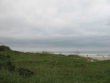 A look at the thickening cloud cover. 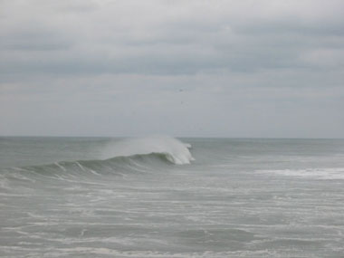 The waves kept rolling in. However, now there was no one out there surfing. 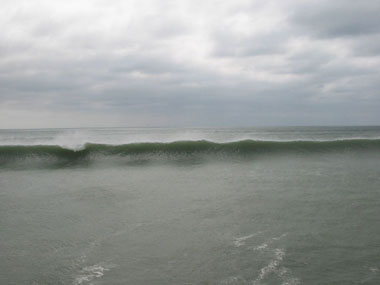 There is nothing like seeing this in person. Now, keep in mind that the wind where we were is blowing FROM the north- or offshore. So these waves were being knocked down a little from the offshore wind. Areas north and east of us, like Cape Hatteras, were receiving onshore wind flow. Their waves were larger and would continue to grow. 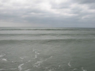 This is what a set of swells looks like.  After the waves break, they leave behind a froth of foam. When the wind is blowing hard from the ocean, this foam blows everywhere. I have seen that during hurricane Floyd from Wrightsville Beach. 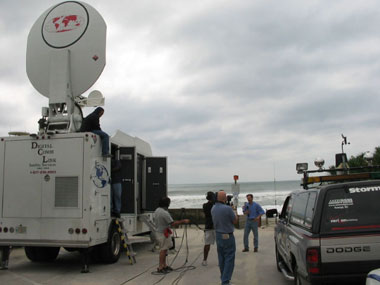 Here is a shot of the CNN sat truck with Jeff Flock preparing for a live shot from Indian Beach- just west of Atlantic Beach, along the southern Outer Banks. By the time we had received the 11am EDT advisory from the NHC, we were certain that our location along Atlantic Beach was justified. Look at the map below. It shows where we were and what the forecast path of Isabel was as of the 11am, Sept. 17 advisory. 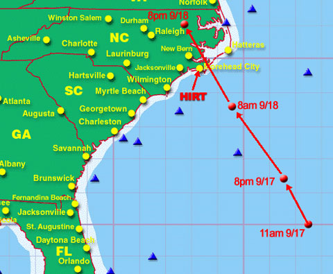 Notice how the track bends to the left just enough so that the geographic center of Isabel would pass just to our east- maybe by 25 miles. This would put us in the western side of the eye. We could have gone further east into extreme eastern Carteret County; however the storm surge risk in that area was too great. I had been out there during Dennis in 1999 and saw how high the water can get along the marshy road leading to Cedar Island. Our team would have been dealing with many more feet of water during Isabel. And, there is nowhere to hide. It's all flat, marsh land with a few towns like Sea Level (big clue as to why we didn't go out there) and Atlantic. So considering the geography, we were in the best place possible to observe and study Isabel. As Wednesday wore on, we moved from our previous location. We were now staying with the fine folks of the Sea Gull Motel near the Triple S Pier. This was several miles east of where we were on Tuesday. Our room was like a small apartment. We set up a wireless Internet field (similar to Wi-Fi I suppose) using their Sprint DSL connection. John, who is our IT guy, could not wait to do that on a mission. It give us a hot spot for our laptops as well as any media who wish to log on at broadband speeds. I kept my laptop in the Tahoe with the Sprint PCS Vision Connection Card running full time. I probably had connection rates of 50 to 80 kbps for the entire duration. That afternoon and evening, we ventured out to see the local terrain. We wanted to scope out a location to put the Tahoe for the maximum amount of exposure. We needed to have open space on all sides of the vehicle when that eyewall passed over. This would allow for better wind data. After stopping in at a local convenient store for more junk food and soda, we went back to the motel to make sure everything was ready for the big day. We did many more radio and TV interviews. It was amazing to see people's interest in our work. Perhaps the most incredible moment came when we were driving down the road near our motel after just finishing up a live shot with CNN. Out of nowhere, an SUV pulls up and two guys jump out and come towards the Tahoe. They were from SkyNews in England. They had just seen us on CNN and wanted to do an interview with us. We invited them to our room to brief them on who we are and what we do. From there, we worked with them several times during the event. As of the 5pm EDT advisory, Isabel was right on course. It was interesting to note in the discussion that in the upper levels of the hurricane, winds were near 140 mph. But there was not enough deep convection or thunderstorm activity to bring those winds down to the surface. There was quite a bit of dry air that had worked its way into the hurricane. It is tough to overcome this dry air and Isabel had little time to really strengthen. It was now time for us to get more rest and prepare for the biggest single day in our history. But getting rest when the wind is really beginning to pick up is easier said than done. I turned in at about 9:30pm or so, maybe a little earlier. The effects of going without much sleep can be like being drunk. Your senses get dulled and you tend to make mistakes in judement. It was very important to get as much sleep as possible. I asked John and Jesse to make sure I was up by the 11pm NHC advisory. As I laid in the bed, I could easily hear the wind whistling in the eaves of the motel. I finally fell asleep and woke up seemingly only minutes later as John came to tell me it was nearing 11pm. I got up and prepared the 11pm update on HurricaneTrack.com. The NHC discussion on Isabel for 11pm still favored a landfall very close to our location. We would likely be in the western eyewall and then the western portion of the eye. Below is the satellite photo taken around 11:45pm EDT on September 17th. 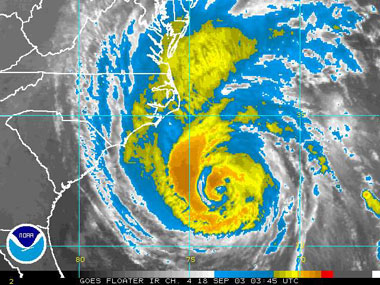 Here is Isabel- still about 12 to 14 hours away. After finishing the update to HurricaneTrack.com, I sent an email to the NHC to let them know where we were and what our current winds and pressure were. They receive a lot of information from HAM radio operators, Internet users and news sources. There were also several university related research missions going on all over eastern North Carolina. The NHC certainly appreciates the data that we send them, but we are by no means the only source of observations out there. Thursday, September 18 I finally tried to lay back down. It was well after midnight. The wind was picking up more and more. Rain was now falling. The tension in the air was getting to be too much. I was laying in the outside room of the motel. Jesse and John each had a double bed in the other bedroom. They were asleep. I was just laying there listening to the wind as it made the bushes and tress scratch at the motel. The rain picked up even more. By now, it was after 1am. I could not take it anymore. I got up and woke up John and Jesse. I told them that we needed to hoist the 6 foot mast on the Tahoe to mount the RM Young anemometer and hook it up to the data logger. It was time to start recording digital data. Once we set up the Tahoe to begin recording wind data, I took out the video camera and shot some great video of wind. Well, I guess the video simply accompanies the AUDIO of the wind. It was perfect. Again, refer to the video gallery and the Isabel clips. By sunrise, the rain was constant. But it was not too heavy. As the NHC mentioned in their discussions on Isabel that there was not a lot in the way of deep thunderstorm activity associated with the hurricane. This would limit the amount of strong winds that would actually make it to the surface. So we did not see the torrential heavy rains with monster wind gusts where we were. There were locations to the north and east of us that did experience these effects. They were also in the right-front quadrant as well. As the day went along, we did news reports and took data from the equipment and sent it to the NHC. We heard from their radio room who fields the reports. They were appreciative and urged us to be safe. It was now about 11am EDT. The latest NHC discussion on Isabel continued to show that the winds higher up were much stronger than they were at the surface. We set out to prove this. We succeeded. Keep in mind that we were on the west side of the large eyewall of Isabel. We had our Tahoe out in the eyewall as it passed over us. The anemometer was at exactly 14.6 feet above the ground. We set everything up and were ready for the eyewall. The wind picked up dramatically as did the rain. However, I have been through several hurricanes and this was not the same. The rain was just not as thick and sheet-like. In a strong, well formed hurricane, with plenty of deep thunderstorms, the rain looks so thick that you cannot see through it. It blasts through in sheets and helps to knock down trees etc. We were seeing something different in Isabel. Being on the west side and thus the weaker side of this hurricane, the effects were not too dramatic. Beyond that, there is not much to tell. Isabel had a relatively weak west side. There was damage, but not much at all where we were. What we did not know at the time was that the north and east side of Isabel was causing a considerable storm surge along the Outer Banks and areas along the Pamlico Sound. We also did not know that Isabel would knock out power to millions of people from the Carolinas north into Virginia, Maryland, DC and beyond. We were well placed so that we had minimal damage and we took very accurate wind readings as far as we can tell. But being on the west side of a shallow convective hurricane will yield minimal effects. We did see some storm surge flooding from Bogue Sound- but not enough to warrant major concern. By Thursday evening, the hurricane had come and gone in Atlantic Beach. Just after the 5pm advisory from the NHC, the back side of Isabel was passing over us. We recorded some of the highest sustained winds during the back side. Keep in mind that we were measuring 1 minute average sustained winds. Our data logger would record wind samples every second. Then, it takes those 60 samples and divides them by 60. The result is an average wind speed for that minute. It also gives us the highest gust during that minute. Most of our wind data showed 55 to 60 mph sustained winds at the height of the western eyewall passage. We had gusts almost to 70 mph. We never recorded a wind reading over 70 mph during Isabel. As we wrapped up our ground work in Atlantic Beach, there was one last interview to do with CNN. There was a dry wind blowing strong from the west now as Isabel was racing inland across North Carolina. Little did we know that millions of people were about to go dark. We also had not heard yet that a new inlet had been cut on Hatteras Island. Indeed, this hurricane that was once such a monster, and that was so hyped by the media, was about to live up to its advance billing. At least 40 people lost their lives in the hurricane from one effect or another. Billions of dollars in property damage took place. People were without power for days on end. It was an extraordinary week for us. I returned home to Wilmington just 3 hours down Hwy 17. John went back to Raleigh via Hwy 70. Jesse, on the other hand, spent the night in a fire station in Elizabeth City. His route took him through the worst part of the wind damage. I am working on getting photos and video from him. But we've all seen it. Trees and powerlines down everywhere. Jesse was stuck in North Carolina and could not get home to Portsmouth, VA for almost a day. We were all affected by the hurricane. Lives were changed and people are beginning to rebuild. The one lesson I hope everyone learned was this: that no matter what the category, one, two or five, each hurricane is different. Each one has the power to change your life forever if you're not ready. Being ready means more than buying the supplies needed to survive. Being ready means understanding what you're up against. Our job is to collect as much information as we can on each hurricane that hits the United States. We then take the data, video and personal accounts with us to teach others what we learned. As I said on television over and over, "if you truly want to learn more about a hurricane, unfortunately, you've got to get out in it." My team and I did just that during Isabel. Next year, we will share with thousands of people what we learned. Then they will have a better idea of what to expect when THEY face a hurricane. They will be ready. I want to thank everyone who emailed us during the event. We were swamped with work to do but tried to email back to as many people as possible. With the Internet, the whole world can reach out and say "Hello". They did just that with us during Isabel. Special thanks go to Lowe's and Sprint for their support. Their belief in our mission is what made this all possible. I look forward to working with both companies next year and beyond. They support our education programs during the "off season". Look for us next year at a town near you as we kick off our 2004 hurricane readiness tour. I'll have more info on that after the New Year. Thanks to all the visitors to HurricaneTrack.com. We had over 2.8 million pageviews during September. It was our busiest month ever. Glad you found the site! Stay with us- you haven't seen anything yet. We have plans for next year that will change how we can report during hurricanes forever. Mark Sudduth Editor and founder of HurricaneTrack.com    |