
|
|  Gathering data
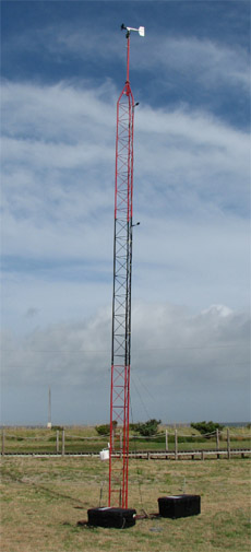
Hurricanes present a unique and challenging set of circumstances that must be considered at great length. Over the years, and thanks to the support of such companies as Lowe's and Sprint, among others, we have acquired the equipment necessary to safely and accurately observe, record, report and document the effects of hurricanes and tropical storms. This equipment includes a pair of 10-meter wind towers that are completely mobile and can be set up in about an hour. We also have nearly a dozen remotely operated cameras that record video back to Storm Case boxes that house an enormous battery, a laptop and video recorders. All of these methods used together can help us to gather weather data as well as visual data about the effects of a hurricane on a coastal area. We use RM Young anemometers for wind speed and direction and Davis Instruments for all other measurements. Our work has been cited in several National Hurricane Center reports and has received national and international media coverage. One of the most important aspects of our work is a digital record of wind and other meteorological data. Through the support of our sponsors over the years, we have been fortunate to accumulate an impressive set of data recording equipment that allows us to not only measure and report wind speeds in real time but also to log this important data every minute for up to 20 hours at a time. It is vitally important for coastal communities that are impacted by hurricanes to have an accurate and reliable data set of exactly what the wind speeds were. Too often, this data is missing or incomplete and people are left with questions as to how strong the winds actually were. We hope to provide at least two data points from our pair of 10-meter wind towers and help to alleviate this void of data. Note that there are other efforts to obtain highly reliable wind data from other organizations such as univsersity wind tower programs and independent research groups. Our data is only a part of the larger picture and we hope our work will inspire others to do the same in an effort to more accurately measure hurricanes at landfall. In addition to our mobile wind towers, we are pleased to have two fully functional weather stations, also at 10-meters, located in coastal Mississippi. The stations are set up in Bay St. Louis at the middle school and in Pascagoula on top of the Jackson County EOC. Each has its own RM Young anemometer, Davis Instruments package and a live web cam. The project was sponsored by Lowe's in 2006 as part of their support of the rebuilding efforts along the Katrina-battered Mississippi Gulf Coast. You may access the various pages containing our live weather data via our homepage under "live weather data". Getting the data out to the world Recorded data is great but allowing the public to access this data in real-time is even better. During hurricanes and even some tropical storms, we provide our data feeds free of charge right here on this site. Through an innovative Java program written by one of our team members, we can display wind speed, wind gust, barometric pressure, temperature, humidity, dewpoint and rain fall- every 60 seconds. In addition to the data, we attach a bullet camera to the wind tower in order to provide a web cam image at least once per minute. This augments the data by showing the site where we have placed the tower. All of this is possible thanks to the generous support of Sprint and their powerful network. We utilize the best in mobile broadband technology from Sprint to send large quantities of data to our web servers during extreme conditions. Our data is available to anyone who wishes to view it and in fact, it is often used on television and radio reports during hurricanes. 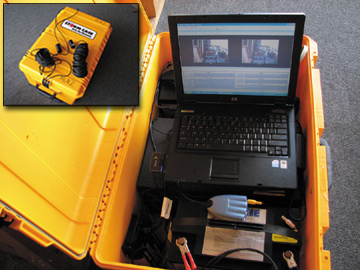 Live streaming video of our missions
Since the 2005 hurricane season, we have been able to stream live video of our hurricane missions straight from our vehicles and our remote cams. This capability allows people to get closer to our work without putting them in harm's way. We have a live camera, complete with audio, placed inside our main vehicle, the Chevy Tahoe. This cam transmits a live stream of everything that we see and hear while on our missions. Anything that happens- our viewers see and hear it live. Additionally, we have developed a highly effective remote camera project that allows us to place tiny high-resolution cameras right at the coast where the worst conditions are expected. These cameras also stream back live video through the gear housed in our Storm Cases. This allows us to place the units in locations where it would otherwise be far too dangerous for us to shoot video in person. Thus, we can capture the effects of storm surge and extreme winds without placing our team at any risk. This paid off during hurricanes Katrina, Rita and Wilma as we were able to capture long-period video from a fixed perspective without putting us in harm's way. We actually lost two of three of our Storm Cases during Katrina due to the violent storm surge that swept the Mississippi coast. By the time we got to Wilma in late October of 2005, we had all but perfected our methods and were able to capture never-before-seen footage of storm surge inundating a coastal community over the course of the event. By using time lapse methods through a computer, we can see the pattern of the surge as it flooded Everglades City, Florida. This video was shown on Discovery Channel, The Weather Channel and has been used by the National Hurricane Center. To view a clip of the video, click the link below. Our live video feeds are reserved for subsribers to our member area. This is one of the ways that we fund our work. We do provide the video streams to local emergency mangement and other relevant government agencies at no charge. We feel this is important as the feeds provide extra sets of eyes, so to speak, in places where having people would be foolish at the very least. To learn more about our member subscription services and to support our efforts, click here. When we are not out tracking hurricanes, we provide talks and seminars about hurricane preparedness. The Team has been to Texas, Georgia, Florida, Louisiana, Alabama, North Carolina, South Carolina and Virginia to talk to people about hurricanes and how to better prepare. We take with us a vast amount of personal expertise because we have experienced what we discuss. Over the past 12 years, even before this site was started, I have worked with local, state and federal programs to promote hurricane preparedness. As my work load grew, I added a small staff consisting of Jesse Bass, Eddie Smith, Mike Watkins, James Lewis and Todd Ferebee. We all work together in an effort to spread the word about hurricanes and how to effectively deal with them. Education is key in helping to mitigate future loss during hurricanes. By putting our years of field experience to use during our presentations, we can better explain the effects of hurricanes and how preparing now can save lives and money later.
Our field missions to date:
THE TEAM:(field crew) Mark Sudduth- Leland, NC Mark has been working with communities and media outlets to produce some of the nation's most comprehensive hurricane tracking maps. He owns Hurricane Maps Enterprises and has worked with media outlets and several local, state and federal agencies to produce hurricane education projects. Mark won an award from FEMA in December 1999 for his work with the Project Impact program. He has been working with Lowe's and Sprint since 2001 on a variety of wide-reaching hurricane education efforts throughout the Southeast and Gulf Coast states. He holds a degree in Geography from the University of North Carolina- Wilmington. Mark is the founder of H.I.R.T. and runs HurricaneTrack.com. Jesse Bass- Portsmouth, VA Jesse joined H.I.R.T. after meeting Mark Sudduth in Wilmington at the 2001 Hurricane Preparedness Expo. Because of Jesse's extensive severe weather photography experience, he was asked to join the team. He accompanied Mark to study tropical storm Barry and hurricane Michelle in 2001. In 2002, Jesse documented H.I.R.T.'s missions for Edouard and Isidore. And this year, he participated in the National Hurricane Conference where he recieved 26 professional development hours in hurricane planning and response. Jesse has taken the National Weather Service SkyWarn training and has even gone out to the Great Plains to photograph tornadic thunderstorms. Visit Jesse's web site: VA Storm Photo.com Mike Watkins - Coconut Grove, FL Mike joined the crew in early 2005. His extensive knowledge of computer models and NHC products allows him to help us with decision making when planning on where to set up for an event. Mike is an analyst for Office Depot and their headquarters in Delray Beach, FL. As such, his math and organizational skills are also superb and help to keep us on track when there are so many duties to undertake. He has his own website, TropicalUpdate.com and posts regular updates there during the season. Mike provides HurricaneTrack.com with news and updates from time to time and will often produce video reports from his home office in Florida. Jonathan Myers- Savannah, GA Jonathan is like Mark in that he too has been a huge weather fan since being a kid. He turned that passion in to a career in television meteorology and now works at WJCL in Savannah, GA. Prior to working in Savannah, he worked along side Skip Waters at WCTI-TV12 in New Bern, NC. Both Jonathan and Mark owe a lot to Skip for being a great mentor over the years. We asked Jonathan to join our crew last season (2006) but have not yet had the opportunity to work with him in the field. He was instrumental in organizing the Lowe's hurricane fair of which WJCL was the media partner in Savannah last summer. We will be working with both Jonathan and WJCL again this year to help prepare the Coastal Empire for their brush with the next big hurricane. Eddie Smith - Kannapolis, NC Eddie Smith is the assistant town manager in Kannapolis, North Carolina. He served as Hazard Mitigation Coordinator and Hurricane Planner for New Hanover County, NC. As hazard mitigation coordinator, Eddie created New Hanover County’s Terrorism Response Plan and helped streamline the response process for hurricane preparedness and recovery. His Hurricane response experience includes Hurricane Bonnie (1998), Hurricane Dennis (1999), Hurricane Floyd (1999), and Hurricane Irene (1999). He was the exhibit chairperson for the 1999 Lowes Hurricane Expo in Wilmington, NC and a committee member for the 2000 and 2001 expos. Eddie has a Master’s in Public Administration from Appalachian State University with a concentration in Emergency Management. He is the published author of Atlantic and East Coast Hurricanes 1900-1998: A Frequency and Intensity Study for the Twenty-First Century published in Volume 80, No.12 of December 1999 Bulletin of the American Meteorological Society. His Hurricane Research trips include Hurricane Floyd (1999) and Hurricane Gordon in 2000. (support crew, education and web programming): James Lewis- Wilmington, NC James is our tried and true "roadie". We have grown so much over the years and have so much gear now that it was impossible for the field team to handle the load without losing valuable time collecting data or working with the media. James is a small engine expert and runs ILM Small Engine Repair in Wilmington. His experience with items such as generators and chainsaws makes him quite the man to have on-site just in case some of our equipment gets rolled up. His easy going nature is a perfect fit to what can be a stressful many days on the road. Todd Ferebee- New Bern, NC Todd is our first intern, if you will, and is by far the youngest of the crew. Todd joined up with us in 2005 for hurricane Ophelia in North Carolina. Since then, he has worked with us on several Lowe's hurricane fairs and consults with us on the latest computer models. Todd aspires to be a degreed meteorologist and is currently preparing for studies at FSU in Tallahassee. The field experience that he obtains by working with us will hopefully give him a better appreciation for the text book meteorology that he will soon encounter in school. Mike Farrow- Wilmington, NC Mike is a well-known DJ for WGNI FM 102.7 and has set the standard for weaving news/weather reports into the music lineup for listeners of the highly popular radio station. Mike will add the benefit of allowing the Team to report back live to the station (and other affiliated stations) during a hurricane or other severe weather emergency. Mike joins up with Mark for the Lowe's Hurricane Readiness Fair tour each year. He was also involved with producing the highly successful Hurricane Preparedness Expos. Jason Secosky- Cary, NC Jason is the author of HurricaneTrack.com's Cyclone Tracking Calculator and our JAVATrack tracking maps. Jason also knows the inner workings of the site well and is quite the pro at getting the computer information we'll need in the field to be ahead of the storm. Jason works full time at SAS Institute in Cary, NC. Dr. Brian Davis- Wilmington, North Carolina. Brian is a professor of physics at the University of North Carolina- Wilmington. We look to Dr. Davis to better understand the physics behind what we observe. Brian accompanied Mark for tropical storm Dennis' arrival in extreme eastern Carteret County, NC. This trip yielded some great video examples of sound-side storm surge during a strong tropical storm. Dr. Davis also advises us on the astronomical tides and solar activity as it relates to our work. MEDIA COVERAGE Our work with the media dates back to 1996 and hurricane Bertha in North Carolina. Since that time, HIRT has been featured on every major television network and many prominent local and national newspapers. HIRT has also been written about and photographed for several international news organizations. For a listing of our media experience, send us an email via one of the links on our homepage. NOTE that we do not charge a fee for appearing either in person or via telephone for a news broadcast. If you are interested in purchasing our video footage, there is a charge that is in line with industry standards. Contact us for more info on obatining video footage for a commercial production.
| If you work in the media, emergency management or other civic organization and wish to contact HIRT for an interview, ride-along, or if you would like to ask us to do a talk or presentation at a school or other civic organization, please visit our email page by clicking here. There is NEVER a charge for HIRT to do a television or radio interview while we are on a mission. 
|